 |
| The
Independent Traveler's
Newsletter
PAGE THREE |
|
| The
Independent Traveler's
Newsletter
PAGE THREE |
Featuring: The Lot département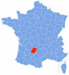 The départements of
France ~ a little history The
département Lot, taken from the province of Quercy, was one of 86 established during the
French Revolution, specifically on March 4, 1790. At that time,
Lot was larger
than it is today, having included the district of Montauban. In
1808, Lot lost a quarter of its area when Montauban became part of the
newly-formed Tarn-et-Garonne. The départements
of France were
officially created to replace the Ancien
Régime provinces, numbering them with 2
digits and in alphabetical order (i.e., 01 is Ain). Départements are each a part
of a larger
region, and almost all are named for rivers, mountain ranges or
coastlines, so the Lot is named for its primary river. The
Lot (46), Aveyron (12), Tarn (81), Tarn-et-Garonne (82), Haute-Garonne
(31), Ariège (09), Hautes-Pyrénées (65) and Gers
(32) are all part of
the administrative region of the Midi-Pyrénées of
southwestern France, a region cobbled together in the 20th century ~
eight départements that don't
necessarily have much in common with one another. The number grew to
the current 95 départements
in France when nine more
were formed in 1860, 1922, 1968 and 1975. There are eleven French
Overseas Départements
known as DOM-TOM (Départements
d'Outre-Mer - Territoire d'Outre-Mer)
with three-digit designations. Credit for
this new system is given to Revolutionary leader Abbé
Sieyès, a clergyman ironically pro-Revolution, although the idea
of départements had been mentioned by others years
earlier. Let's Visit the Lot
Our
visits to the Lot have always
been memorable and very pleasant ~ from tiny Martel to
the drama and history of Rocamadour, and from the Grotte de Presque to
St-Cirq Lapopie. The
rugged landscape ~ with two major rivers, the River Lot and the
River Dordogne, and smaller tributaries such as the River
Célé, River Bave, and River Céou ~ includes
the hilly terrain, gorges, prehistoric caves and steep cliffs of the Parc Naturel
Régional Causses du Quercy
which comprises much of the département.
Your
time
here is enveloped in beauty and nature at its best. The River lot has its source in the
Cévennes and travels westward 299 miles before emptying in the
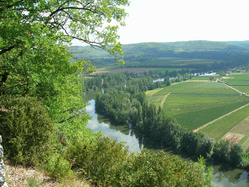
Garonne River. It is a winding, beautiful waterway with many
towns and villages perched on hills above or on its banks. Some
of those worth visiting are Puy l'Evêque, Luzech, the road to
Crayssac (where this photo was taken), Cahors, and St-Cirq Lapopie.
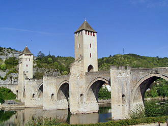
Be sure to take Le Petit Train de Cahors for a
great 45-minute ride to explore the city. You will visit old
streets and take in its rich history. Commentary will be provided
to describe the buildings, the Roman vestiges and more. Add
another ticket to include the one hour fifteen minute cruise around the
city, under the Valentré bridge and relax as you see it from
another vantage point. The cruise is available from April to
October.
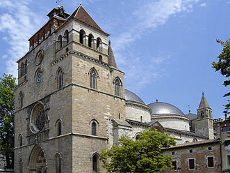
Cathédrale
de St-Etienne
Pont de Valentré
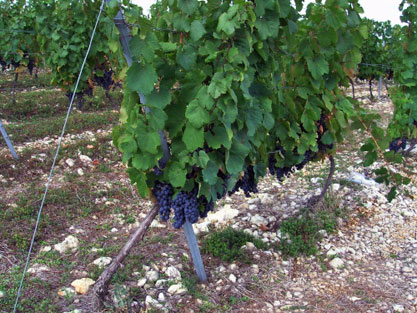
Wine made from dark, purple Malbec
grapes has its origins in Cahors for which the region is famous.
The rich, 'black' wine of the Lot takes is name from this important
town, and Cahors Malbec has become very popular around the world in
recent years. But, it isn't new. Cahors winemaking began
with the Roman arrival in the Lot about 50 BC. The rich wine of
Cahors had a stellar reputation from the Middle Ages until the
phylloxera epidemic devastated the area between 1883 and 1885.
Then, when a severe frost struck in the winter of 1956 destroying most
of the vineyards, they all had to be planted again. It was at
this time that the Malbec grape became more dominant, and Cahors wine
was awarded AOC classification in 1971 requiring a minimum content of
70% Malbec grapes for this appellation. Today, many Malbec wines
come from Argentina, and the vignerons
of Cahors have developed an association with those South American
vintners whose grapes originated in France. Wine experts can
distinguish between the Malbec from Cahors' gravel-y, limestone,
terraced terroir (shown in
this photo) which they say has more structure, firmer tannins and is
darker ~ and the fruitier, smoother-textured Argentine Malbecs.
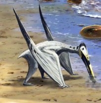
Crayssac, just 10 minutes west of
Cahors on the D811, has something special to see: Pterosaur Beach
~ a place without sand or water, but a unique paleontological
experience with Jurassic period footprints left behind by shellfish,
crocodiles, turtles, lizards, pterosaurs, dinosaurs and many more
creatures that lived here 150 million years ago. This site has
provided scientists with definitive evidence that pterosaurs were
quadrupeds, not bipeds, as previously assumed, and the prints left
behind demonstrate how all the various creatures moved along the
sand. France is very rich in prehistoric sites, and this is but
one of them found in the Lot.
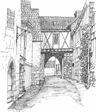
Martel's 'skyline' is distinctive
for its seven medieval towers. There is Musée de Uxellodunum, a
local Gallic archeological site that was besieged in 51 BC by Julius
Caesar himself. It is difficult to confirm that the commune of
Martel is named for Charlemagne's grandfather, Charles Martel, who
drove the Saracens out of France. But, it is suggested that he established
the village, gave it his name and helped build the Church of Saint
Maur. Another hypothesis comes from one Jean Vidal who goes
further and says, "Charles Martel, who defeated the Saracens in
734-735, had built the Church of Saint Maur to the place called since
Martel, in memory of the victory he had won in this place." It
seems that Vidal may have a few of his facts wrong, as the battle
against the Saracens he refers to by date was in Narbonne and not in
Quercy. In any event, the village is quite pleasant,
historic links notwithstanding. This drawing shows one of its
charming streets.
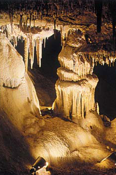
Humans have
inhabited Quercy since about 400,000 years BC, but around 40,000 years
BC the colonization by Cro-Magnon man took the place of the last
Neanderthals. They used caves and rock shelters in the valleys
and camped on plateaus. Their cave art, vast networks of
underground caves, and megalith burial sites which came about 3200 and
2000 BC tell us much about their lives and culture. Some
twenty prehistoric sites have painted or engraved artwork, and the Lot
has
the third largest number of megalith monuments in France ~ about 500. Some of the
most important sites to visit are the Grotte
du Pech-Merle, near Cabreret northwest of Cahors and not far
from St-Cirq Lapopie, and the Grottes
de Cougnac a few kilometers north of Gourdon. One other site not
to be missed is the chasm, Gouffre
de Padirac, about 14 kilometers northwest of Rocamadour.
This is a round hole 30 meters in width by 75 meters deep. It was
an underground cave whose roof collapsed, stopping the flow of an
underground river. Since its discovery in 1889, several
expeditions have visited the twenty-one galleries. Visit their
web site for some incredible photos and information about visits
and tours.
continued
on page 4
|
|
| |
|
 previous
page
next page previous
page
next page |